On the chart, Alexandria sits west of the canal entrance, not at it. That small separation matters when sailing to the Red Sea: arriving in Egypt and being ready to enter the Suez Canal are different achievements, separated by another stretch of coast, another set of instructions and another decision about when to move. A route written as a sequence of port names conceals these intervals. On board, the intervals are where most of the work happens.
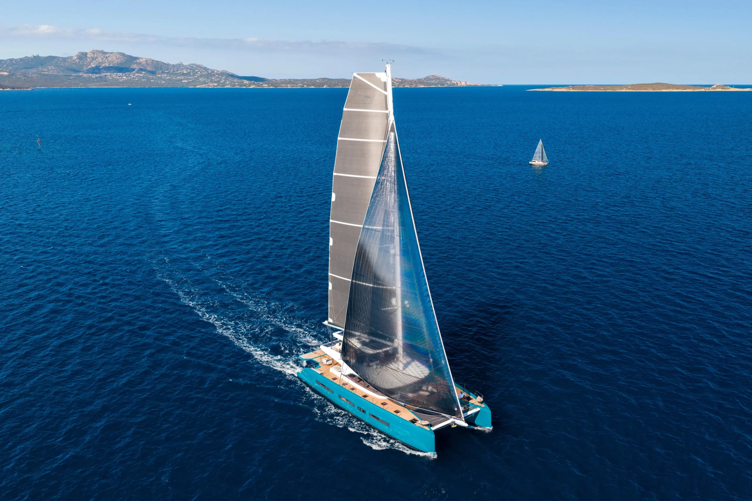
Our prelude is the passage east before Naora begins in the Red Sea, sailed from January to April: Palma de Mallorca to Valletta, Valletta to Alexandria, Alexandria into the Red Sea, and onward through the Red Sea to AMAALA in Saudi Arabia. The boat is Discovery, a 2025 Lagoon EIGHTY 2 sailing catamaran. Sven, Naora’s founder and captain, plans every weather window and sails every leg himself. The word prelude locates this passage in the larger story. It does not reduce the attention it requires. The sea makes no allowance for what we have decided to call the opening chapter.
The route for sailing to the Red Sea
Palma to Valletta is roughly 600 Nm before weather routing and harbour approaches alter the track. Valletta to Alexandria is roughly 820 Nm. These are planning distances, not promises about the distance recorded in the log. A diversion to avoid an uncomfortable sea, a wider approach to a traffic lane or a decision to seek shelter can add miles without representing a navigational failure. Sometimes the longer line is the more competent one.
The useful conversion is from distance into exposure. As an illustration, 600 Nm at an average of 8 knots means 75 hours under way. That is arithmetic, not a performance prediction for Discovery. It tells you that a departure forecast cannot be considered in isolation: the boat will still be out there several nights later. A passage plan needs conditions along the route, the likely arrival conditions and somewhere practicable to go if the forecast changes. A harbour on the chart is not automatically a refuge. Its entrance may be exposed to the very wind you need to escape.
January to April describes the span of the prelude, not four months of continuous sailing. Time alongside belongs inside the plan because clearance, maintenance, provisioning and waiting cannot all be compressed into the hours left over after movement. Nor does a workable forecast establish that a passage is otherwise acceptable. Port acceptance, permissions, insurance conditions and current maritime security advice require separate checks, repeated close to departure. Weather is one source of permission. It is never the only one.
Winter weather when sailing to the Red Sea
The Mediterranean in winter does not offer a dependable conveyor belt east. Depressions move through, fronts change the wind, and the mountains around the basin accelerate air into particular corridors. A mistral episode originating around the Gulf of Lion can send a substantial sea into the western Mediterranean. By the time the local wind eases, the waves generated elsewhere may still be arriving. Looking only at the wind arrows can make a departure appear considerably kinder than it will feel beneath the hulls.
A useful habit is to read wind and waves as separate forecasts. Beaufort force 5 corresponds to a mean wind of 17 to 21 knots, but that description does not specify the gusts, the swell direction or the wave period. Waves of similar height arriving six seconds apart will generally be steeper than waves arriving ten seconds apart. On a catamaran, meeting a short, steep sea can produce abrupt pitching and impacts beneath the bridgedeck. The cost appears in reduced speed, disturbed sleep and the difficulty of doing ordinary work while every loose object is trying to move.
Wind angle changes the problem again. Twenty knots of true wind arriving 120 degrees off the bow is a different sailing condition from twenty knots arriving at 60 degrees. Boat speed changes the apparent wind felt by the sails, and a course chosen for progress may place the waves at an unhelpful angle. Sometimes easing the course reduces the impacts enough to justify the extra distance. Sometimes reducing sail or speed is the better answer. Neither decision can be made from wind strength alone.
Reefing on a large cruising catamaran should follow the boat-specific guidance for wind strength and angle, with allowance for gusts and sea state. Heel is a poor warning system compared with what many sailors learn aboard monohulls. Waiting for the boat to feel dramatically overpressed can mean waiting too long. If the forecast makes a reef likely during the next watch, taking it while there is light and rested help available may cost some speed now and save a difficult manoeuvre later. A weather window is useful when it leaves room for these decisions, not when it requires everything to go exactly as predicted.
What a recently built sailing yacht still has to prove
A build year tells you when a boat was made. It cannot tell you everything about how that boat behaves after several nights of motion, with the galley working, navigation equipment running and people trying to sleep. Harbour checks establish that equipment operates under the conditions of the check. A passage introduces combinations of load and movement that are harder to reproduce alongside. We need to distinguish between knowing that a system works and knowing how to live with it.
That distinction makes the log important. Recording battery state, charging activity and significant electrical loads can reveal whether the energy balance matches the expectation. A percentage on a battery display is useful, but it needs to be read alongside what is drawing power and what has actually replaced it. The practical question is how long essential services can continue if a normal charging source becomes unavailable. Finding the answer while everything is working leaves options that discovering it during a fault does not.
The same discipline applies to water in the bilges. A known dry baseline makes a new trace meaningful. Salt water, fresh water and condensate suggest different sources, although identification should come from tracing the system rather than guessing from appearance. Before opening strainers or working on plumbing, the relevant isolation point has to be understood and accessible. An unfamiliar valve is a small inconvenience in daylight. It becomes a much larger problem when the boat is moving and someone is already tired.
This is part of what the prelude is for: allowing observations to become operating knowledge. A recurring noise gets located. A locker that does not retain its contents in a seaway gets corrected. The written handover becomes more precise. None of this requires a dramatic failure. Reliability often grows through attention to things that have not yet become serious enough to insist on it.
Watchkeeping and sleep on an overnight passage
A watch schedule allocates attention, but it also allocates the opportunity to recover that attention. Four hours off watch does not mean four hours asleep. There is a handover, something to eat, perhaps wet clothing to remove, then the time required to settle into a moving berth. Someone who lies down for only part of that interval cannot be treated as rested simply because the rota shows a blank space beside their name.
The appropriate rotation depends on the competent people aboard and the demands of the passage. A four-hour watch that is manageable in settled weather may be too long when repeated squalls, shipping and sail changes require continuous concentration. Protected rest means that an off-watch person is not routinely recruited for work that can wait. Sven’s responsibility for every leg does not mean that the captain should attempt to remain awake throughout it. It means the watch has clear instructions about when to call him, early enough for the call to preserve choices.
A handover should transfer the situation, not merely the seat. Course and sail configuration matter, but so do approaching traffic, changes in the wind, unusual equipment behaviour and the next planned navigational decision. A contact that looks harmless now may matter during the following watch. Saying where it is, how its bearing is changing and what action has already been considered prevents the incoming person from having to reconstruct the last hour.
AIS helps, but it does not replace a lookout or radar. Not every vessel transmits it, and a displayed closest point of approach depends on courses and speeds remaining sufficiently steady. One observation is particularly worth carrying away: a vessel whose compass bearing stays nearly constant while its range decreases presents a collision risk. That needs repeated observation, not a single glance at a screen. Self-steering holds a course. It does not take responsibility for where that course is leading.
Alexandria and the Suez Canal transit
From Alexandria, Port Said lies roughly 130 Nm farther east along the Egyptian coast. Port Said is the Mediterranean entrance to the canal. Arrival at Alexandria therefore does not place a yacht in a canal queue, and clearance into one port should not be assumed to settle the formalities for the next movement. The practical sequence has to be established with the relevant authorities and agent before the boat moves: where to report, where to wait, which documents are required and what constitutes permission to proceed.
For the transit, vessel particulars and certificates, dimensions, draught, crew documentation and the required administrative arrangements need to be ready. Convoy arrangements, reporting times, pilot changes and any tug or line-handling requirements belong to the current instructions of the Suez Canal Authority, confirmed through the agent. They should not be copied uncritically from someone else’s account of a previous transit. A useful travel story can become poor operational guidance when a procedure has changed.
The canal itself is roughly 100 Nm long and has no locks. Ships pass between the Mediterranean and the Red Sea at sea level, rather than being lifted over a difference in elevation. That does not mean the water is motionless. Currents occur, with tidal influence particularly relevant towards the southern end, and wind can affect water movement. The pilot’s local knowledge is valuable, but it does not remove Sven’s responsibility as captain. Position, speed, machinery and surrounding traffic still require the boat’s own attention.
In confined water, the important comparison is not simply between the sizes of two vessels. It is between their available choices. A deep-draught ship may be unable to leave the dredged channel, while the water outside that channel is not automatically safe for a yacht. Large ships also generate water movements that can affect a smaller vessel nearby. Instructions about spacing and position have physical reasons behind them. Fenders, lines and the working deck need to be ready before they are requested, because searching for equipment is a poor use of the short interval between an instruction and the moment it must be carried out.
Wind and reef navigation in the northern Red Sea
South of the canal, the Gulf of Suez leads into the northern Red Sea. This is a different weather setting, but it should not be mistaken for guaranteed settled water. Northerly and northwesterly winds are common, and the surrounding terrain can strengthen the flow along the gulf. Winter weather systems can interrupt that pattern. A following wind may help a southbound boat while building a sea that makes an exposed stopping place unsuitable. Progress offshore and comfort at anchor can point towards different decisions.
Reef navigation adds a limit that cannot be negotiated through speed. Water colour can provide information: pale sand often appears turquoise, while coral heads may look brown or dark. But clouds, glare, depth and the character of the bottom alter those appearances. Dark water may be deep water or something much closer to the surface. Colour is evidence to compare with the chart and the depth sounder, not an independent guarantee of clearance.
The useful procedure is to plan the approach for good light, keep the sun in a position that supports observation where practicable, maintain a dedicated visual lookout and move slowly enough to retain options. The depth sounder measures beneath its transducer; it does not survey the water ahead. Its displayed figure must also be understood: an offset may make it report depth below the transducer, below the keel or relative to the surface. Confusing these references can consume a supposed safety margin before the boat reaches the shallowest point.
Where anchoring is permitted, confirmed sand gives a different prospect from coral, rock or seagrass, and adequate swinging room matters as much as the depth beneath the bow. Local restrictions and environmental protections take precedence over an apparently convenient patch of water. The approach to AMAALA likewise depends on current permission and the assigned arrival arrangements. A clear-looking gap in a reef is not, by itself, an invitation to use it.
What arrival at AMAALA actually completes
AMAALA gives the prelude an endpoint on the Saudi Arabian coast. Reaching it completes a geographical task. The work aboard continues until the boat is secured, arrival formalities are settled and the defects or observations from the passage have somewhere definite to go. A note that says only to check a noise later is easily inherited and easily postponed. A useful note records where it occurred, under what conditions and what still needs investigation. Finishing a passage includes leaving the next departure an honest account of the boat.
There is a quieter arrival that does not appear in those records. After several days of motion, a person can continue making small allowances for movement even when the berth is still. A hand holds the cup a little longer. A foot waits before committing its weight. The body has learned something without asking for a lesson, and does not immediately surrender it because the lines are ashore. For a while, the cup is safe on the table and the hand remains beside it.