The first thing to look for at Carthage from the sea is the rise of the land, not a row of columns. Low ruins can disappear against newer buildings and vegetation. The higher ground holds its shape. Before the eye finds anything recognisably ancient, it finds the reason a sailor would have noticed this coast in the first place: land beside a gulf, with access to the routes running through the central Mediterranean.
That distinction matters. Carthage is sometimes described as though its history stands intact along the waterfront, waiting to be read from a passing yacht. Much of what makes the site remarkable lies low, inland or beneath later occupation. Some of it requires walking. Some requires knowing what is missing.
For us aboard Discovery, the useful habit is to let the coast be itself before asking it to illustrate a story. This is a living Tunisian shoreline, not an abandoned stage set. The ancient city belongs to it, but does not occupy the whole view.
Reading Carthage From The Sea
From a low viewpoint on the water, separate layers of a coast collapse into one another. A wall near the beach and a building farther inland can seem almost adjacent. An elevation that looks modest on a map becomes the feature by which the whole shore is recognised. This is why an archaeological plan and the view over a yacht’s bow can appear to describe different places.
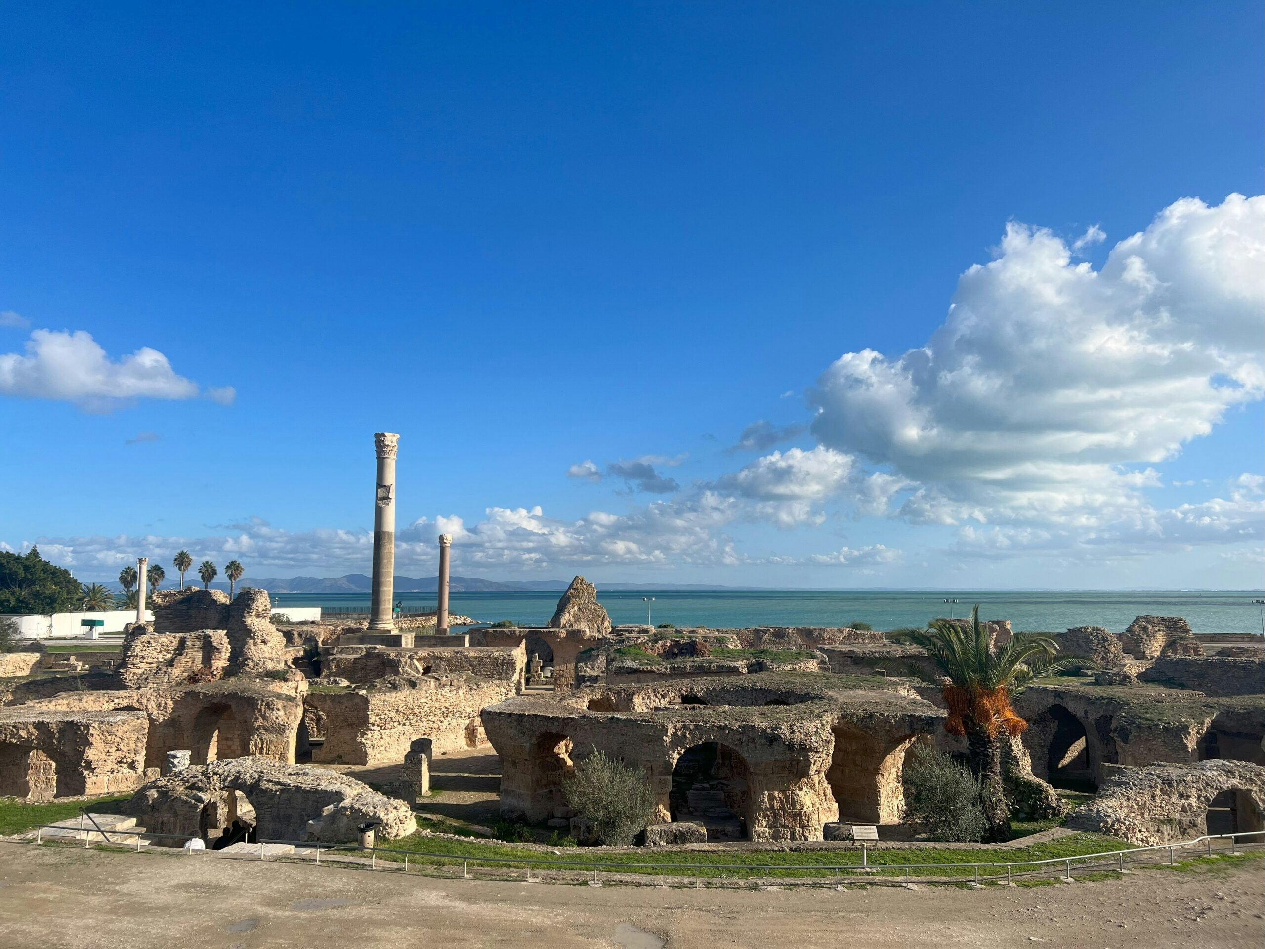
The Antonine baths, the substantial Roman bath complex beside the sea, offer a more plausible visual reference than a mosaic floor or the foundations of a house. Even there, visibility depends on angle, distance, haze and the light behind the shore. Recognising the site is different from understanding its surviving rooms. Binoculars help with the first. They cannot provide the second.
The famous circular military harbour needs particular care in the telling. Its surviving basin is something to understand on a plan and explore from land. It is not a great circular indentation announcing itself in the open coastline to every passing vessel. To promise that view from deck would be to confuse an aerial photograph with a sailor’s eye.
With low sunlight on the water, brightness can erase rather than reveal detail. The eyes narrow, the binoculars press against the brow, and the pale shore seems to lose depth. Turn away briefly and the darker cockpit takes a moment to return. In those conditions, wanting a better look is understandable. It is not a reason to bring the yacht closer than the navigation allows.
The Geography Before The Battles
814 BCE is the traditional foundation date of Carthage, rather than a precisely established anniversary. The settlement was founded by Phoenicians from Tyre, carrying maritime knowledge into a position that connected North Africa with the wider Mediterranean trading network. The important fact for a sailor is less the apparent precision of the date than the intelligence of the location.
Carthage stood near the meeting of the eastern and western Mediterranean worlds. That did not mean every ship had to pass beneath its walls. Maritime influence depended on a network of ports, trading relationships, productive land and the ability to maintain ships and crews. A commanding position was an advantage, not a substitute for organisation.
A fleet needs somewhere to be repaired. A trading vessel needs somewhere its cargo can be handled without every passing wave interrupting the work. People need fresh water, food, rope, timber and the skills to turn those materials into another departure. The city’s agricultural hinterland mattered alongside its waterfront. The sea connected Carthage to distant markets, but the land helped keep its people fed.
This is the part of a maritime civilisation that we find easiest to recognise from a working yacht. The famous voyage sits on top of less famous preparation. Someone has checked the stores, found a damaged fitting, waited for a delivery or decided that the wind makes tomorrow a better day. Ancient ships and a modern sailing catamaran have little in common technically. Their dependence on work done before departure is familiar.
What The Harbours Were Built To Do
The surviving Punic harbour arrangement is usually understood through two connected basins: an outer, broadly rectangular commercial harbour and an inner circular naval harbour. The distinction makes sense when considered as a working system rather than an attractive shape.
Commercial activity requires access. Goods have to move between vessels, storage and the city. Naval activity brings different needs, including protected maintenance space and control over who can enter. Around the circular basin, and on its central island, the naval facilities provided space associated with housing and servicing warships. The geometry was part of the work.
An enclosed harbour reduces exposure to waves and concentrates access through an entrance. That makes loading and repairs more manageable. It also creates a dependency. An entrance can become congested, damaged or blocked. A protected fleet still has to get out to sea. Shelter and freedom of movement are not quite the same thing.
Nor should the surviving arrangement be projected backwards across the whole history of Carthage. Harbours develop. Shorelines change. Structures are repaired, replaced and adapted to vessels and needs that their first builders could not have anticipated. What remains is evidence of particular phases, not a complete working model of every century.
Looking at the basins with this in mind changes the visit. The circle stops being merely picturesque. It becomes a way of organising labour, protecting expensive equipment and making departures possible. Behind the history of naval power sits the quieter history of people keeping boats in service.
The Destruction And The City That Followed
Rome destroyed Carthage in 146 BCE, at the end of the Third Punic War. The killing, enslavement and destruction were real. The familiar claim that the Romans then salted the ground is a later myth, not an established part of what happened. It adds a memorable image to an event that needs no embellishment.
Leaving that image out matters because it makes room for the more difficult history of the place. Carthage did not remain permanently empty. A Roman city subsequently grew over the defeated Punic city and became an important centre in its own right. Much of the monumental masonry a visitor encounters belongs to that later Roman life.
The Antonine baths date to the second century CE. Their scale speaks of a city with the resources to bring in water, heat rooms and maintain an elaborate public building. A bath complex required fuel, drainage, cleaning and continuous labour. The surviving spaces are impressive, but the missing daily work is what makes them comprehensible.
At the waterfront, the body supplies a small part of that understanding. Sun reaches exposed stone; shade under a surviving wall feels distinctly cooler. The breeze can dry perspiration before the walk feels strenuous. It becomes possible to think of bathing as a bodily need in a warm city, rather than simply another category of Roman monument.
The distinction between Punic and Roman remains is useful, but the ground is more complicated than a clean pair of layers. Later occupation, rebuilding, disturbance and excavation have all shaped what is visible. Carthage asks for attention to fragments. A floor survives without its room, a foundation without its wall, a harbour without the vessels that explained its dimensions. We should resist completing all of it too confidently in our minds.
Planning A Passage In The Gulf Of Tunis
The historical interest of a coast does not change the order in which we assess it. Sven, Naora’s founder and captain, plans every weather window and sails every leg himself. Along the Tunisian coast, as elsewhere, that means reading the forecast alongside the chart, the actual sea state and the options available if conditions deteriorate.
The Gulf of Tunis is open towards the north and northeast. For a particular stretch of shore, however, exposure depends on its orientation, the direction of the wind and the distance over which waves have had room to build. A coast can look sheltered on a small-scale map and still receive an uncomfortable sea from the wrong quarter.
Cooler-season Mediterranean weather can bring rapidly changing conditions with passing depressions. In warmer, settled weather, daytime heating can support an onshore sea breeze. Neither observation is a timetable. The larger weather pattern can strengthen, suppress or alter a local breeze, and a pleasant morning does not establish what the afternoon will be like.
We also distinguish wind from the water it has already set moving. A breeze can ease while swell persists. In shallower water, waves change shape and may become steeper. For people aboard, that difference can mean a quiet-looking forecast but an awkward approach, or a shore transfer that is less comfortable than the passage itself.
The gulf also serves working ports. Commercial approaches, charted restrictions and fishing activity deserve more attention than the photograph someone hopes to take. AIS helps us understand equipped traffic, but it does not show every small boat or piece of fishing gear. Looking out remains a separate job from looking at the coast.
At an illustrative speed of 6 knots, the yacht covers 1 Nm in ten minutes. That is enough time to become absorbed in identifying a ruin, and little enough for the relationship between the yacht, another vessel and the shore to change substantially. The practical answer is to keep the navigation and lookout continuous while others enjoy the view. Historical curiosity is welcome aboard. It does not take the watch.
Going Ashore Without Assuming An Anchorage
A coast worth seeing is not automatically a coast where we can anchor. That decision begins with current charting, local requirements and any restrictions affecting the water, followed by depth, bottom type, shelter and room to manoeuvre. Archaeological interest supplies none of those answers.
Although astronomical tides in this part of the Mediterranean are relatively modest, charted depth is not identical to the water available at every moment. Wind and atmospheric pressure can alter water level. Wave motion also affects clearance. Before relying on a sounder reading, we need to know its reference: depth beneath the transducer, beneath the keel, or an offset intended to show depth from the surface. Confusing those readings can consume a margin that appeared generous.
Holding ground needs equally careful interpretation. A pale patch seen through the water may suggest sand, but colour alone does not establish either the bottom or its suitability. Where anchoring is permitted, we look for appropriate ground while avoiding seagrass and any protected or archaeologically sensitive area. Scope then depends on the full vertical distance from seabed to bow, the conditions expected and the swinging room available. Extra chain does not correct a poor choice of location.
Going ashore is another decision again. Formalities, an authorised landing place, the forecast for the return and the ability to recover everyone safely come before an afternoon among the ruins. A manageable outward transfer can become difficult after an onshore wind builds. The return deserves planning while the water is still easy.
Ashore, care becomes simpler but no less important. Carry drinking water rather than assuming it will be available inside the site. Wear footwear that tolerates uneven ground. Leave fragments where they lie and keep off fragile masonry. Outside the archaeological areas, remember that homes, streets and places of worship belong to everyday life. Ask before photographing people. None of this makes the visit less intimate. It gives the place room to remain itself.
What Carthage From The Sea Leaves With Us
Discovery, the Lagoon Eighty2 sailing the Naora Global Expedition, will move around the world across the five years from 2027 to 2031. Within that continuous voyage, members of Naora’s private circle choose when they join, where along the route they step aboard and how long they stay. The yacht continues while the people aboard change.
That freedom makes time worth discussing honestly. Someone joining for a week may care deeply about a particular afternoon ashore. Someone staying longer may be content to wait through unsuitable weather. Neither preference changes the conditions. What we can do is make the distinction between an intention and a promise clear, and give decisions enough room that disappointment does not become pressure on the boat.
Carthage is a good place to understand why a coastal passage and a visit ashore offer different things. From the water, geography is immediate and the archaeology incomplete. On land, individual structures become legible, while the wider maritime setting can slip out of attention. Each view needs the other. There is no need to pretend that passing offshore amounts to knowing the city.
What holds our attention longest is the harbour entrance. Beyond the wars and the names, it was an opening through which people expected ships to return, carrying provisions, news and someone who had been away. The buildings around it could be monumental. The expectation was ordinary.
Even in a ruined city, an entrance still suggests a return.